First Prejury: All-in-One

Last week we had the first prejury of the semester. In my proposal my aim was to design a house composed of different boxes with different functions.

Screen Shot 2015-04-14 at 11.21.55

The blocks’ location, being back and forth or up and down could solve the natural lighting problem of the site by maximizing the surface. They are also provide the entrance, a shelter and a terrace.

Screen Shot 2015-04-14 at 11.40.20

The circulation between boxes are defined with two different approaches. The boxes with similar functions such as living room, bedroom, kitchen (house parts, yellow boxes); or showroom, meeting room, study room of the user (office part, blue boxes) have the circulation in themselves. And the house and office parts are connected to themselves with a different box functioned as a circulation box (green boxes). You can see the movement through the boxes in the section and plan drawings.

Theo Van Doesburg and “De Stijl” Movement

For ARCH222 History of Architecture II course, we were all assigned a differeny text and expected to present and discuss all relevant and important names, cases, issues, ideas and etc. In my research paper I referred Theo van Doesburg and other associated artists, regarding “De Stijl” movement and their first manifest “Manifesto I”.

Screen Shot 2015-04-14 at 10.40.22

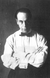
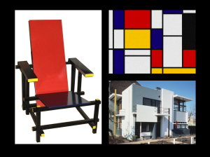
He is a Dutch painter, architect, designer, writer, decorator, poet, and art theorist.  In 1915 van Doesburg discovered Piet Mondrian and published an enthusiastic account of his work. He find in Mondrian’s work a new and holistic way of painting: the abstraction of the reality. Van Doesburg admires Mondrian’s painting so much that he started to see abstract painting as a higher and more spiritual level in painting. Through the following few years Doesburg’s style rapidly developed from Post-Impressionist to abstract.

Screen Shot 2015-04-14 at 10.42.49

After he met Mondrian, he got in contact with other like-minded artists, whom later will be a part of the De Stijl movement. He discusses his ideas with the architect Oud and with the painter Huszar. At the same time he was in touch with the painters Mondrian and Van der Leck. And in 1917, they all founded the magazine “De Stijl”

Number of artist from different fields and different disciplines come together under a mutual desire to create a new style of the arts. Van Doesburg pointed out that the various artists had more in common: ‘the need for abstraction and simplification.’ The important fact about this development is, that the three painters of De Stijl, Van Doesburg, Van der Leck and Mondrian, each originally had his own special corner in the field of art and so were able to furnish different contributions to their common cause, ‘De Stijl’.

Screen Shot 2015-04-14 at 10.45.06

Number of artist from different fields and different disciplines come together under a mutual desire to create a new style of the arts. Van Doesburg pointed out that the various artists had more in common: ‘the need for abstraction and simplification.’ The important fact about this development is, that the three painters of De Stijl, Van Doesburg, Van der Leck and Mondrian, each originally had his own special corner in the field of art and so were able to furnish different contributions to their common cause, ‘De Stijl’.

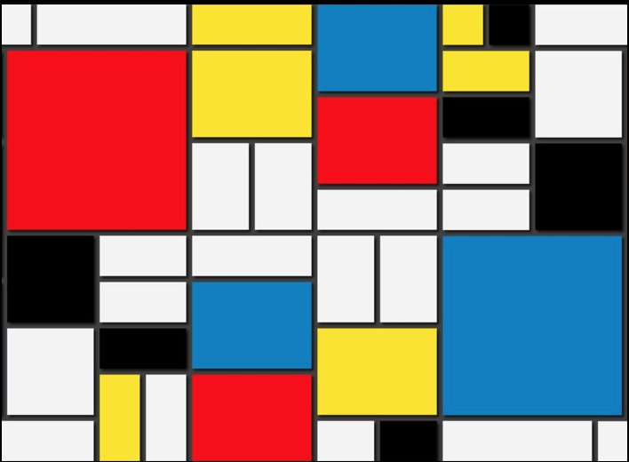
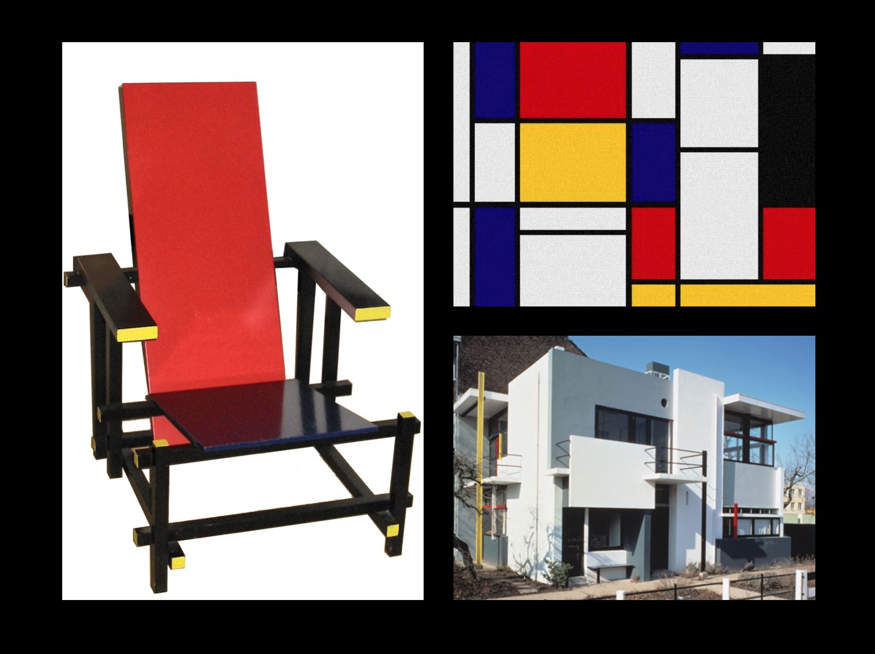
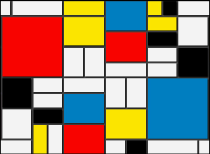
The idea of De Stijl is an “absolute” concept, they dedicated to developing a universal aesthetic, intellectual and spiritual unity to art, architecture and design. The “absolute” is the cornerstone of De Stijl and it can only be expressed by the abstraction. To this end, artist’s personality completely eliminated by using straight lines, right angles and particular colors. Traditional artistic representations, limited to more or less casually selected fragments of the material world, as seen through an individual’s senses and personality, were to be distrusted and disregarded. John Nixon summarise this thought by stating: “Traditional artistic representations, limited to more or less casually selected fragments of the material world, as seen through an individual’s senses and personality, were to be distrusted and disregarded. Instead, with the traditional limitations, encumbrances and distractions set aside, a new pure art would emerge, expressing by its formal relationships the very essence of things.” De Stijlists, therefore, excluded all individual life and they tried to create more universal form of life, aimed the universality of the essentials of form and colour.

In 1918 they published their first manifesto, “Manifesto I”.

Screen Shot 2015-04-14 at 10.49.45

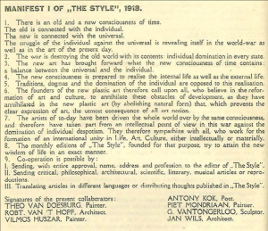
In general, the manifesto is reflecting both current world and the changes in the art world regarding the shifting in dominance and power caused by the war. The effects of the war can easily be interpreted nearly all the clauses existing in manifesto. Besides, the emergence of the De Stijl movement itself also coincides with the crucial period of the war. In such circumstances impacts of the war to the ideology is quite understandable. In the first clause it says, “The struggle of the individual against the universal is revealing itself in the world-war as well as in the art of the present day.” This quote is simply reflecting their desire of creating something completely new in art instead of what the world had offered so far. In that respect, the whole manifesto written in a way that explains their thought on trying to change the style within art and how art was made.

Tag Cloud

For each studio day, we were asked to produce a “Tag Cloud”, consists of the words have been using during the critics, juries, discussions etc. Here is an example that I made for the first week.

Tag Cloud_Melis Kucuktunc_24 March

Kayaköy Workshop Design

We were assigned to design a workshop for the industrial designer, who will spend 4 months of the year in this workshop according to our scenario. We had already measured and produced the autocad drawings of the given building with the exact dimensions. In my design I aimed an open space, which will be used only for working and exhibition. The roof of the building was totally destroyed so I decided to design some strips come from the ground level and in the upper parts create the roof itself. The strips will not only provide shelter and the roof but also any other components of the house. It will be used especially as walls, which will also defines the entrance of the building. It will be used as the floor, and upper level a terrace. The staircase and every other partition in the house will also provided by this strips. The originality of the building will be preserved, and the strips will not touch to the existing building. I also design this strips as a solid massive black material which will create a very contrary appearance consisting both ancient and the modern. Here are the drawings of my design.

Field Trip to Kayaköy, Fethiye

As the first and second architecture students, we visited Kayaköy, which is an abandoned ancient village in Fethiye. Thousand of people lived here since 18th century until early 20th century. People had to leave the village because of the population exchange between Greece and Turkey. Later it was devastated by an earthquake in 1856 and a major fire in 1885. Now the village serves as a museum and is a historical monument.

The aim of this trip was producing survey drawings of the given building, which is something we are all experiencing the first time. So it has been a challenge to measure mostly destroyed building with the traditional methods. Here are some photos of the building we were assigned to study on.

Interaction Matrix and Spatial Scenarios

We were asked to study the user patterns and decide on a scenario for the house through a graphic layout. In my scenario, there are two permanent  users of the house, -the main user is already assigned as an industrial designer-. And there is one temporary but regular user: the assistant, who only use the house in the weekdays. Also there are temporary users who visit irregularly, the customers and the clients.

Pictogram

Accordeon Drawing Sketchcard: #HOUSE

This semester we started to produce “Accordeon Drawing Sketchcards” the Text, Building, Diagram Series. The first step of the ADS was the concept “House“. We were asked to analyse 10 projects given and produce a series of spatial interaction and organisation diagrams. I have assigned the projects below:

UN Studio / Van Berkel & Bos, Möbius House, (1998), Villa Wilbrink (1994)
Le Corbusier, Unite d’ Habitation, (1947-52), Villa Curutchet,(1949)
Tadao Ando, Azuma House, (1976)
Preston Scott Cohen, Torus House , (1999)
Diller+ Scofidio, Slow House, (1991)
Rem Koolhaas / OMA, Villa Dall’Ava, (1991), Dutch House (1995), Maison a Bordeaux (1998)

Site Survey: Siteler

For second year’s final project, we were assigned to design a #HOUSE in the industrial district of Ankara, Siteler. Therefore, as usual, the first step was the Site Survey. We observed various factors as site forces; for example, topography, landscape (river, hill, water), green areas (parks, playgrounds, trees), traffic roads, climate, etc. And we interpreted and document the information from the site, updated the plan drawing, draw the different sections and finally we produced a 1/200 model of the site.

Plan Interpretation

First assignment of the Studio Course for the 4th semester was the study called plan interpretation. We were asked to consider this plan as a section of the house we are designing. The spatial and structural organisations of the house should studied according to this vertical section. It is, in fact, a very efficient way to practice our visualisation and 3D designing skills.

plan

Urban Planning in Ancient Egypt

Introduction

More than 4000 years ago, the story begins with the village life of farming and animal husbandry in the highlands above the Nile Valley. With especially the influence of their religion and believes, there was created one of the most significant cities in the history of architecture.

Ancient Egypt has many features when compared with the other civilisations in that time. This superiority comes with a denser population and their higher level of social development. When we compare the social context of Ancient Egypt and other civilisations in such an early stage, we can easy observe the sophisticated level of culture, art and architecture.

Until the recorded history, Egypt governed and ruled separately: as Upper Egypt and Lower Egypt. At the very end of what we had called in the last chapter the Protoliterate Period, that is about 3000 B.C., King Menes of the Upper Egypt invaded the north and unified the country.(1) This unification and setting a new capital at Memphis coincide was a significant event for the people of the region. People had to make some changes with their dwellings and hence it lead them to have a great improvement on the Egyptian architecture. Then, the pharaohs and builders were started to involved more with the idea of “urban planning” and design their cities as proper settlements.

Defining Urban Planning

Urban planning designs the settlements from the smallest towns to the largest cities, from the past to today. It can be defined as designing the layout of the city considering the technical, political and social concerns. Haverfield defines urban planning as an art of laying out towns.(2) It guidesthe settlements in a more orderly way and brings an order to the city in many aspects and provide the efficient layout for the comfort of inhabitants.

As a dictionary definition, urban planning means “design and regulation of the uses of space that focus on the physical form, economic functions, and social impacts of the urban environment and on the location of different activities within it.”(3)

In today’s approach to the urban planning the focal points are more about industrial and commercial efficiency. As the density of the population increases and with the effect of the industrialism the forms of the cities have altered. People are started to settle with regarding to those issues. According to Trigger, however, the social dynamics of ancient states were quite different from those of modern states.(4)

Throughout the history, settlements are always located by the water; in order to produce, to eat and to make their livings easier. At the earlier stages of the human civilisation,

the necessity of planning the city came from the demand of achieving maximum usage of the land, water and the other natural resources. People choosing watersides to settle can be the simplest and most obvious example for this demand.

Therefore in the history, the purpose of city planning is the optimum usage of the land and resources in order to locate the settlements accurately. Urban planning also aims to improve the usage of the land, water and other natural suppliers.

On the other hand, one should not forget that urban planning is not only resulted by the land and its characteristics but also it has shaped according to some political aspects. Some might resulted from the deliberate actions of ancient rulers and their architects. Those plans, buildings and more importantly monuments conveys some meanings and communicate various kinds of messages. Briefly, the urban planning might not just about the land itself but have an intention by the ruler.

Urban Planning in Ancient Egypt and its References

The coordinated arrangements describes that every individual architecture features in a city take their references from one another, they arranged and constructed in that way. (5) For instance, all structures in a city may share a common orientation.

One of the reasons behind such planning
could came from the intention of the ruler, as it’s mentioned above. Capital cities in ancient states typically combined formality with monumentality. It is obvious that when one thinks about the Ancient Egypt the first thing comes to the mind is Egyptian Pyramids: which are considered to be the world’s oldest monumental structures. The significance of pyramids for Egyptians cannot be underestimated in terms of neither religious nor political sides: since ancient kings built huge pyramids, palaces and other monuments to promote some ideological messages. In a very similar aspect, Smith believes that “The specific purpose of ancient rulers, many architectural and spatial features of ancient cities served to communicate middle-level meanings.” The term “middle-level meaning” means that the concern of the transmission of messages about identity, status and power.

However, the common orientation among the architectural features of the city does not necessarily imply central planning due to monumental structures, because the other factors such as topography and natural resources could produce a same pattern. In the case of Ancient Egypt, this factor is directly related with the Nile River.

The Nile River has played an extremely important role in the civilization, life and history of the Egyptian nation. As indigenous people, Ancient Egyptians make their livings from the village life: the farming and animal husbandry. And hence Nile means the source of most of the water and fertile soil.

Providing better climatic and habitable conditions were the major factors to

encourage Egyptians for a development of civilisation in the Nile Valley.(6) To the Egyptians, Nile was the life and the desert was the death, that’s why they choose the Nile Valley to be settled. “Then in time it is transformed into a sophisticated pattern of river settlements based on controlled irrigation.”(7)

The main fact of the common orientation in Ancient Egypt is having located with respect to the Nile River. Therefore; the Nile acts as an axis: a great axis that ran for hundreds of miles. “

In one sense, everything along the banks was linked to everything else by the Nile axis. That was the major highway of the country. (8) The general layout of the settlements are the things ran along the Nile and right angles to it. So the Egypt can be defined as an orthogonal city with axes, straight lines, paths and right angles.

Orthogonal Layouts

Orthogonality or the “grid” pattern describes the use of right angles in the layout of buildings and cities.(9) As in Ancient Egyptian plans have the same approach, they can be labeled as orthogonal region.

Most urban historians identify planned cities through the presence of orthogonal layouts.(10) Because they believed that orthogonality is the most sophisticated way to design a urban layout. Though there are degrees of orthogonality as we can observe the examples from another settlements.

For instance there exists a pattern which resembles orthogonality but does not reflect a perfect orthogonal grid. Some historians named it as “semi-orthogonal urban blocks”. It occurs in dense settlements in which each individual house abuts one or more other houses, such as Çatal Höyük and at numerous densely settled ancient cities. (11)

This kind of a layout results from the individuals who make their dwellings as an addition to an existing structure. So not only the political powers originate an urban planning but also the simple factors generate those patterns.

According to the Barry Kemp’s study in order to clarify the levels of the orthogonality, there compared two examples of urban planning: as a simulated urban growth pattern (a) and urban blocks at Amarna, Egypt. (b)

The reason why semi-orthogonal plans occur is distortion of the layout according to the differentiations of the topography or some natural factors. So that there occurs more than one orthogonally planned zones in a single city.

However, those kinds of alterations do not mean that the urban planning of the Ancient Egyptian cities were less organised or less developed. On the other hand pyramid town of Kahun provides perfectly orthogonal plan in a modular way.

Ancient Egyptians using orthogonal layout might also be resulted from the general geometrical approach in the Egyptian cities. Of course the main reason must be the shape of the Nile River, but they were also unfamiliar with the circular shapes. Only thing they know and are familiar was the 90 degreed layouts.

Conclusion

In conclusion, the various kinds of urban planning at the ancient ages resulted from more than one reasons. In the case of Ancient Egypt we can connect the urban planning with the actions of ancient pharaohs and the topographical conditions. And hence the Ancient Egyptians were practised this system with the orthogonal layout, which they became very successful.

Geometric master plans were unique to Egypt at this early date.(12) It proves how Ancient Egyptians improve themselves in architecture and urbanisation. Using such plans created by individual pharaohs were like the evidence for that improvement. As Joseph Rykwert said that before: “All the great civilisations practice orthogonal planning”(13)

Sources

1. Kostof, Spiro. A History of Architecture, New York and Oxford: Oxford University Press, 2010.
2. Haverfield, Ancient Town Planning, (London: Oxford at the Clarendon Press. 1913) p.5
3. Encyclopaedia Britannica / Urban Planning
4. Trigger, Bruce G., Understanding Early Civilisations (New York: Cambridge University Press, 2003)
5. Smith, Michael E., Form and Meaning in the Earliest Cities: A New Approach to Ancient Urban Planning, (Arizona State University) p.8
6. Butzer, Karl W. “Geo-archeological interpretation of Acheulian calc-pan sites at Doornlaagte and Rooidam (Kimberley, South Africa).” Journal of Archaeological Science 1.1 (1974): p. 9
7. Kostof, Spiro. A History of Architecture, New York and Oxford: Oxford University Press, 2010. p. 67
8. Kostof, Spiro. A History of Architecture, New York and Oxford: Oxford University Press, 2010. p. 70
9. Keith D. Lilley, Urban Life in the Middle Ages 1000-1450 (New York: Palgrave, 2002)
10. Smith, Michael E., Form and Meaning in the Earliest Cities: A New Approach to Ancient Urban Planning, (Arizona State University) p.12
11. Smith, Michael E., Form and Meaning in the Earliest Cities: A New Approach to Ancient Urban Planning, (Arizona State University) p.15-16
12. Kostof, Spiro. A History of Architecture, (New York and Oxford: Oxford University Press, 2010)
13. Joseph Rykwert, The Idea of a Town: The Antropology of Urban Form in Rome, Italy and the Ancient World